Little known waterfalls around Montara Mountain and adjacent hills
From Pacifica south to Montara.
San Pedro Valley County Park
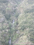
- waterfall at (37.5685, -122.4827):
Name: Brooks Falls
gps coordinates estimated from map, reliability unknown

Video:
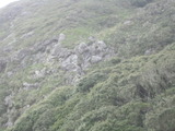
The closest I could get without going through unreasonably dense bushes was the vista point on the Brooks Creek Trail 1000 feet north of the falls. It might be taller than what I've measured due to parts that are hidden in bushes. It may have a trickle of water most of the year, but it's only worth seeing for a couple of days after several inches of rain.
Beauty: 7.5
Duration: 20 days after a significant rainfall
Height 190 feet give or take 20 feet
Number of drops 3
Terrain: dense bushes
Last visited 2012-03-17
id: montara.1
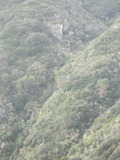
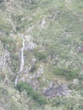
- waterfall at (37.569668, -122.483323):
gps coordinates estimated from map, reliability unknown
in lower right corner:
Video:
Visible from vista point for seeing Brooks Falls
Beauty: 6
Duration: 2 days after a significant rainfall
Height 30 feet
Biggest vertical drop 30 feet
Number of drops 1
Terrain: dense bushes
Last visited 2012-03-17
id: montara.2
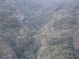
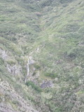
- waterfall at (37.5697, -122.48555):
gps coordinates estimated from map, reliability unknown
near middle:
Visible from the Montara Mountain trail just before it starts up the steep rocky section. The waterfall is about 140 yards southeast of the view point. It probably continues down farther than I was able to see.
Beauty: 5
Duration: 2 days after a significant rainfall
Height 23 feet
Terrain: cliffs
Last visited 2012-03-17
id: montara.3
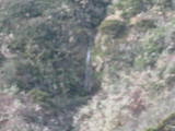
McNee Ranch State Park
- waterfall at (37.57, -122.4886):
gps coordinates estimated from map, reliability unknown
Video:

Visible from the Montara Mountain trail.
Beauty: 7
Duration: 5 days after a significant rainfall
Height 50 feet
Biggest vertical drop 25 feet
Terrain: dense bushes
Last visited 2012-03-17
id: montara.4
back to main waterfalls page


