Waterfalls around Marin Headlands
The part of the Golden Gate National Recreation Area in Marin County from Mt Tamalpais State Park to the Golden Gate Bridge. The Tom Harrison map for Southern Marin covers nearly all of it.
Golden Gate National Recreation Area
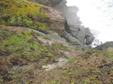
- waterfall at (37.83462, -122.54638):
the top taken 2011-03-06:
the lower part of the waterfall, seen from another cliff:
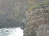
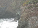
My estimate of the height is more suspicious than usual, because I can only see parts of it at one time from above. There is little hope of getting a better view from land, but it shouldn't be unusually hard to get a better view from the water.
Beauty: 7
Beauty: 8 (including beauty of the hike to the falls)
Duration: 2 days after a significant rainfall
Height 35 feet (broadly defined)
Height 30 feet
Biggest vertical drop 10 feet
Terrain: unofficial trail, some difficulties
route: From the Rodeo Beach Parking, follow one of the trails going west near the cliff tops almost to Tennessee Point. I don't recommend trying to get a good view of the top. Stick to viewing it from a moderately good trail that goes out toward a point atop a cliff 100 yards east.
Last visited 2011-03-06
id: headlands.1
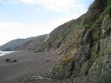
- waterfall at (37.823540, -122.506154):
taken 2019-01-31:

Video:
Beauty: 4
Beauty: 9 (including beauty of the hike to the falls)
Duration: 3 days after a significant rainfall
Height 10 feet
Biggest vertical drop 2 feet
Terrain: beach
route: near the east end of Black Sands Beach
Last visited 2019-01-31
id: headlands.2
back to main waterfalls page


